Surrounding Area
This page is dedicated to the surrounding area of Cerrillos, which is rich in history.

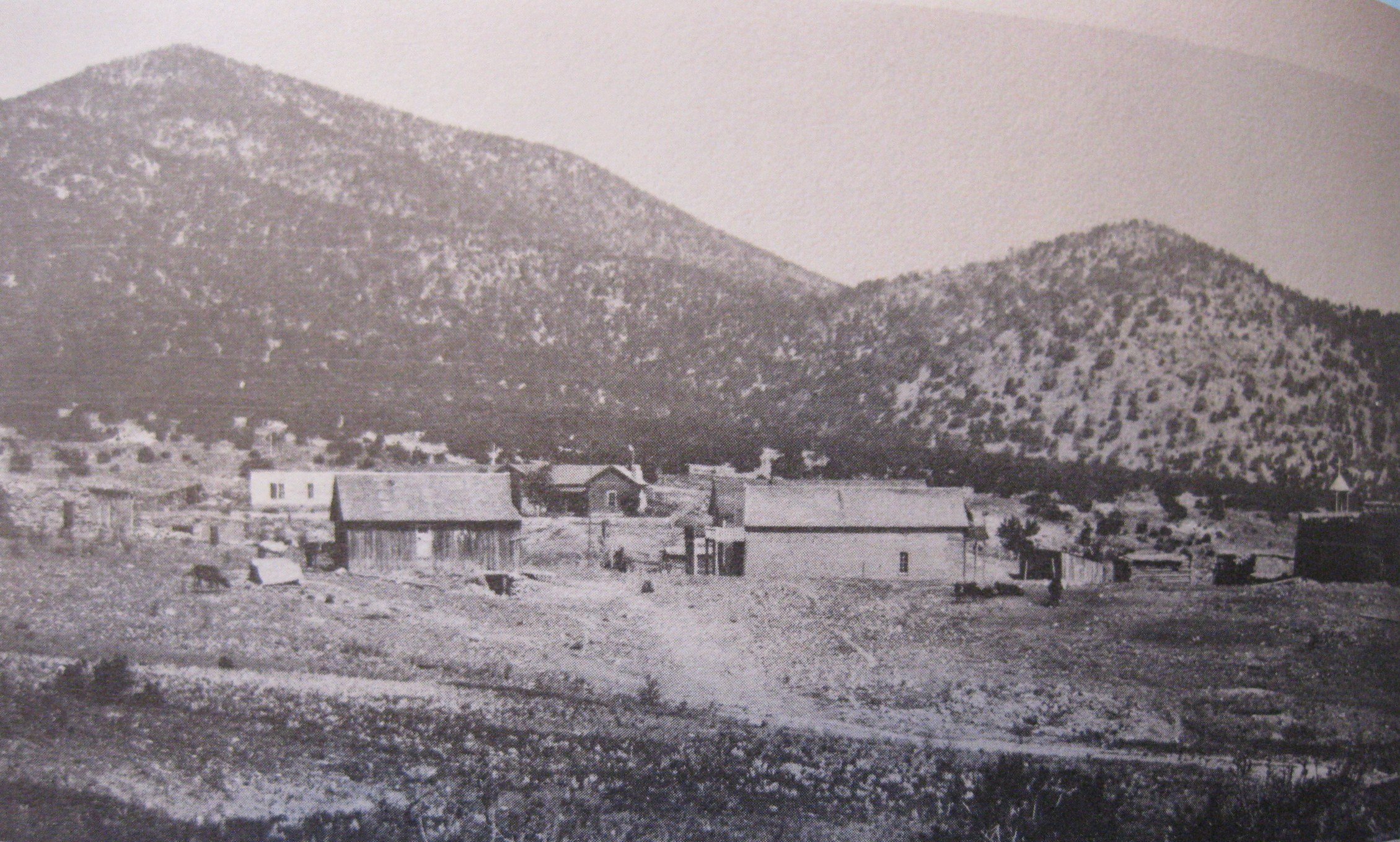
Waldo
From Cerrillos drive over the railroad tracks, turn left, and drive over Devil's Throne. Waldo is 2 miles west of Cerrillos on CR 57.
Waldo was a place along the Santa Fe right-of way until 1892, when a spur line originating there was built down to the coal mines at Madrid. Named for Henry L. Waldo, then chief justice of the New Mexico Supreme Court, the town eventually had a population of about 125. The principal industries were the ovens, built by the Colorado Fuel and Iron Company that produced coke for smelting. Waldo died when the Madrid coal mines closed in 1954. Today you can see the foundation of the old train station, large cottonwood trees and the remains of the coke ovens on the west side of the tracks.
Dolores
Located on private property. You can not visit this site.
Placer gold was discovered in 1822 or shortly thereafter in the Ortiz Mountains and Dolores mining camp sprang up. Twenty years before the California gold rush - New Mexico experienced its own gold rush. By the early 1830s the gold quartz veins, the source of the placer deposits, had been discovered, and starting in 1833 they were developed by two wealthy merchants, Jose Francisco Ortiz and Ignacio Cano, on the Santa Rosalia lode about a mile up the hill from Dolores. The poplulation figure for 1870 listed 150 people at Real de Dolores. Thomas A. Edison erected a large plant at Dolores in 1900 to extract gold with static electricity though it failed.
A wonderful cowboy song about the town of Real de Dolores del Oro was written by James Grafton Rodgers (1881-1971) and sung by Katie Lee. Rodgers was born in Denver CO where he spent most of his life, except for a stint as Assistant Secretary of State in the Hoover Administration. He was a lawyer, public servant, civic leader, international financier, diplomat, expert in military intelligence, historian, teach, educational administrator, author, researcher, playwright & songwriter.
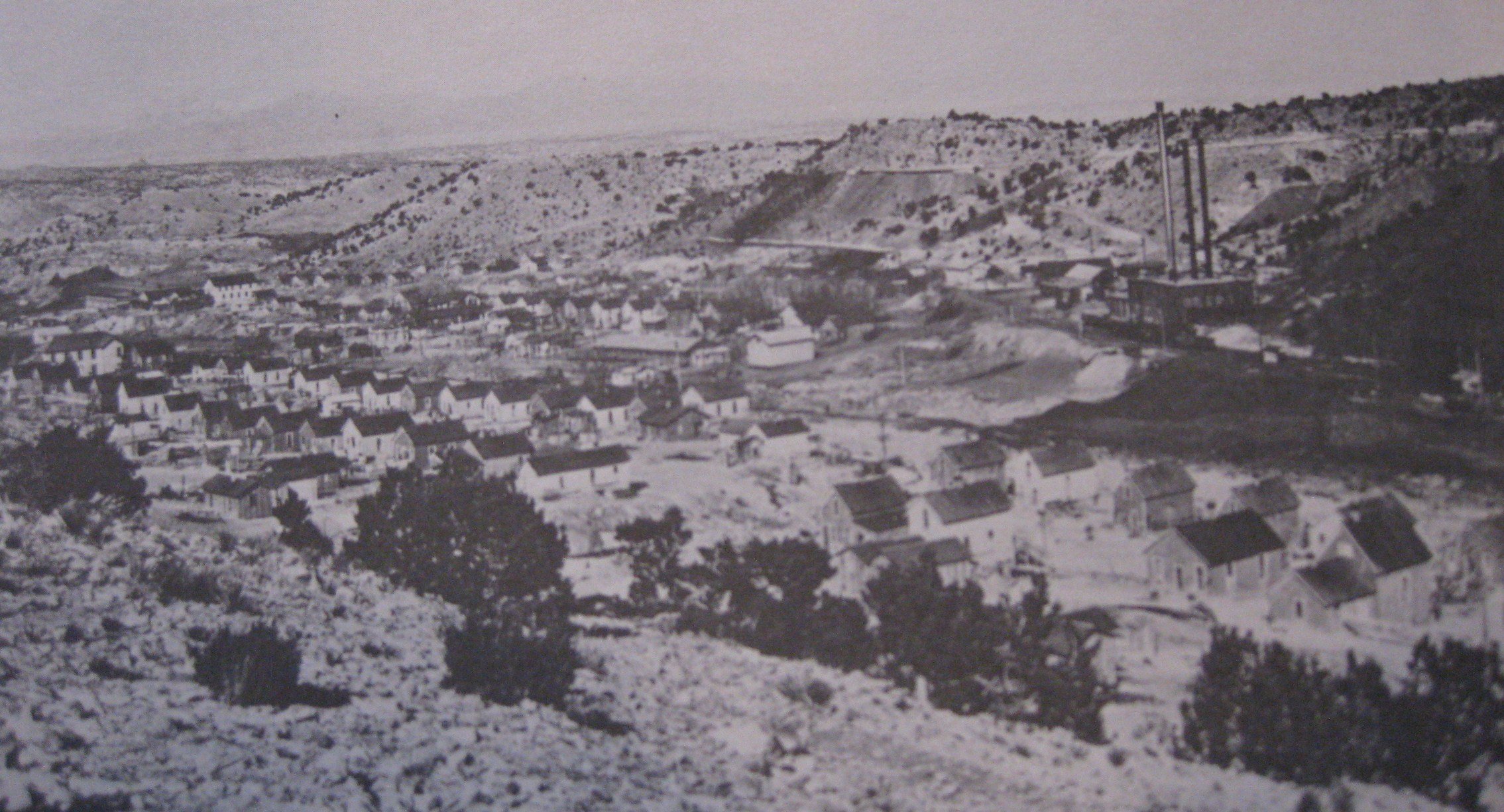
Madrid
3 miles south of Cerrillos on Hwy 14.
Madrid prospered as a coal mining town. Mines produced both anthracite and bituminous coal. Significant mining probably started around 1835. Intermittent and small scale mining continued until 1892, when the tract was sold to the AT&SF. That year saw the beginning of the town of Madrid and coal production on an industrial scale reaching its peak in 1920. From 1906 to the 1960s it was owned and controlled by the Albuquerque and Cerrillos Coal Company. Coal production all but stopped in 1954. Today a lively art & craft town on the Turquoise Trail.

Golden
14 Miles south of Cerrillos on Hwy 14.
El Real de San Francisco developed in the 1840s as a result of placer gold deposits discovered at the base of San Pedro Mountains. By the 1880s the town had been renamed Golden and by 1882 Golden consisted of three general merchandise stores, a hotel and the Madden & Maxwell saloon. Two years later the town had 400 residents and expanded with a newspaper, a stage, a constable, shoemaker, blacksmith,justice of the peace, lawyer and 2 stamp mills. The gold boom was over by the mid-1880s and the mines lay idle. Golden has a few residents; Henderson Store and ranching continues in the area.

San Pedro
15 miles south of Cerrillos, turn east on Hwy 344. San Pedro was on both sides of the road.
1846 active placer gold strike in progress. A formal townsite was laid out in 1880 with a merchandise store, 3 saloons, hotel, dwellings for 300 residents. 2 miles east the San Pedro mines opened extracting copper from the rich sulfide ore. In 1887 a new strike rekindled the mining fever and San Pedro went into a new era of prosperity.
New buildings sprung up and several new businesses. The mines at San Pedro have long since closed, leaving only a small battery of beehive coke ovens, a few shattered foundations, and a cemetery which is on private property.

Galisteo
12.6 miles southeast of Cerrillos. Drive north from Cerrillos and turn right onto CR 42. Galisteo is 8.8 miles.
The oldest surviving Spanish name for a town in New Mexico. The name Galisteo (a man from Galicia) was applied by Capt. Chamuscaso in 1571. The current church replaces an older one which was built around 1820. Galisteo has several attractions for those who enjoy historic old towns; a museum formerly the Ortiz y Pino hacienda and cemetery. Most of the adobe homes have been attractively preserved and renovated. A detour north on Hwy 41 will take you to the village of Lamy.

Carbonateville
This site is on State Trust land and closed to the public.
Originally Dimick and Hart’s Camp, by the spring of 1879 Carbonateville was the center for mining activity in the Cerrillos Hills. Carbonateville functioned under a post office of the same name for only 1 year. The post office was changed to Turquesa in 1880 but was still more often refered to as Carbonateville. It was located in the Cerrillos mining district atop a deposit of silver carbonate. Great things were expected of the booming mining town, but the arrival of the railroad and the building of Cerrillos Station two miles away, together with the lack of water resulted in the abandonment of Carbonateville. Very little remains today of what was for a couple of years one of the largest towns in New Mexico.
Rogersville
4 miles southwest of Cerrillos on private property.
Rogersville was named for William C. Rogers, who after the demise of Carbonateville became involved in mining bituminous coal there. When the AT&SF RR acquired the Madrid Tract in 1892 Rogers continued his mining, but now under lease. About the time Colorado Fuel & Iron Co. took over mining operations on the Madrid Tract, 1896, Rogers was forced to leave. But the district still carries his name.There was a spur to the community from the Santa Fe Railroad mainline. Low rock ruins remain today.

Bonanza City
6 miles north of Cerrillos. This site can be viewed from the highway but is on private property.
Bonanza City burst into being in 1879, founded by J.J. Mahony and Samuel Hull. It quickly became the center of the Gonzales mining district, which was almost as quickly absorbed into the Cerrillos mining district. At one time hundreds of people crowded into the camp seeking the bonanza but as what happened so often in New Mexico, most of their dreams were not realized. By the 1890s Bonanza City, or La Bonanza it was later known, was home for the workers of the nearby Tiffany and Castilian turquoise mines. Today just the foundation from the old Duryee lead concentrator can be seen.

Lamy
18 miles north east of Cerrillos on Hwy 285.
Settlement on the Burlington Northern Railroad. The tracks arrived at Galisteo Junction in January 1880. Several months later the name was changed to honor Archbishop Lamy; Lamy Junction. The rail junction was at a village in the center of the Lamy Land Grant, 16, 547 acres that archbishop Lamy had taken in trust for the Catholic Church and the junction was named in his honor and a spur line was built into Santa Fe. Amtrack stops at the station daily and a tourist train, the "Santa Fe Southern" has a round trip ride to the station from downtown Santa Fe using the spurline.

Hagan
15 miles south of Cerrillos and 10 miles west on a dirt road, Puertocito Rd.
Coal deposits found along the arroyo brought Hagan into existence in 1902. About 60 people lived near the mine. A railroad line was not completed until 1924. At this time, 500 people lived in Hagan and large company buildings were built along the arroyo. The town also depended on cattle ranching and a brick plant. The coal seams thinned out and the post office closed in 1931. The adobe & brick ruins are posted "No Trespassing" but you can view them from the road.

Coyote
3.2 miles northwest of Hagan.
Coyote was founded in 1904 by miners working the Sloan Mine. The prospect of a railroad spur linking the community & nearby Hagan to the Santa Fe line helped keep the town going. Townspeople watched two rail projects die and before the line was completed to Hagan, Coyote was already a ghost town. Ironically the spur line came within a half mile of the ghost town. Several foundations stand at the site.

Kennedy
20 miles south of Santa Fe, 2 miles west of Galisteo.
This site is on private property. Post office from 1906-1918. The abandoned settlement was located where the old New Mexico Central Railroad (formerly the Santa Fe Central RR), also known as the Frijole Line, crossed the AT&SF Railroad. Kennedy was named after Arthur Kennedy, a Senator from Pennsylvania and NMC RR official. The last run of the NMC was in 1944, from Estancia to Willard, the junction with the Union Pacific RR. The 100-year old Kennedy depot building serves today as the activities center for the community of El Dorado, but the “Kennedy” name has been painted over with “El Dorado”.

La Bajada
20 miles south of Santa Fe on I-25, west on CR 16, turn into La Bajada.
La Bajada means the gradual descent. The Santa Fe Trail that linked Santa Fe and Albuquerque dropped seven hundred feet from La Bajada mesa in about one mile of switchbacks and hairpins turns. The town La Bajada was an important stopping point for wagons, stages, and later automobiles. A service was available where you could hire someone to drive your Model T up or down the dangerous switchbacks, in reverse, the strongest gear, while you negotiated the grade the safe way by walking it.
The population was around 300 until 1932, when the road was rerouted up a gradual grade 5 miles southeast of town. This farming community had several stores and a Catholic Church. A few families remain.